


Voting District 28, Rogers County, Oklahoma
About
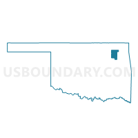
Outline

Summary
| Unique Area Identifier | 655127 |
| Name | Voting District 28 |
| County | Rogers County |
| State | Oklahoma |
| Area (square miles) | 12.76 |
| Land Area (square miles) | 12.72 |
| Water Area (square miles) | 0.05 |
| % of Land Area | 99.62 |
| % of Water Area | 0.38 |
| Latitude of the Internal Point | 36.19624960 |
| Longtitude of the Internal Point | -95.78579230 |
Maps


Graphs
Select a template below for downloading or customizing gragh for Voting District 28, Rogers County, Oklahoma


Neighbors
Neighoring Voting District (by Name) Neighboring Voting District on the Map
- Voting District 10, Rogers County, OK
- Voting District 110, Rogers County, OK
- Voting District 111, Wagoner County, OK
- Voting District 130, Rogers County, OK
- Voting District 155, Tulsa County, OK
- Voting District 23, Tulsa County, OK
- Voting District 25, Rogers County, OK
- Voting District 43, Tulsa County, OK
- Voting District 756, Tulsa County, OK
Top 10 Neighboring County Subdivision (by Population) Neighboring County Subdivision on the Map
- Tulsa CCD, Tulsa County, OK (569,469)
- Coweta CCD, Wagoner County, OK (52,698)
- Catoosa CCD, Rogers County, OK (24,115)
Top 10 Neighboring Place (by Population) Neighboring Place on the Map
Top 10 Neighboring Unified School District (by Population) Neighboring Unified School District on the Map
- Tulsa Public Schools, OK (284,811)
- Owasso Public Schools, OK (45,456)
- Catoosa Public Schools, OK (11,288)
Top 10 Neighboring State Legislative District Lower Chamber (by Population) Neighboring State Legislative District Lower Chamber on the Map
- State House District 74, OK (48,540)
- State House District 98, OK (44,506)
- State House District 77, OK (34,596)
Top 10 Neighboring State Legislative District Upper Chamber (by Population) Neighboring State Legislative District Upper Chamber on the Map
Top 10 Neighboring 111th Congressional District (by Population) Neighboring 111th Congressional District on the Map
Top 10 Neighboring Census Tract (by Population) Neighboring Census Tract on the Map
- Census Tract 504.05, Rogers County, OK (3,676)
- Census Tract 504.08, Rogers County, OK (3,002)
- Census Tract 504.07, Rogers County, OK (2,354)
- Census Tract 59, Tulsa County, OK (2,342)
- Census Tract 504.06, Rogers County, OK (2,263)
- Census Tract 304.03, Wagoner County, OK (1,897)
- Census Tract 504.09, Rogers County, OK (1,822)